Download Information About Mineral Resources
Service that allows you to download various information about Mineral Resources.
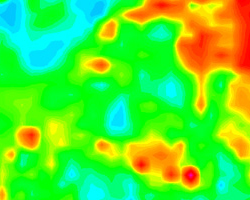
Radiometric Map of Continental Portugal
Year : 2017
This document summarizes current knowledge about natural radioactivity in mainland Portugal. Mapping the country's natural radiation provides support for prospecting mineral and geothermal resources, geological mapping and hazard studies.
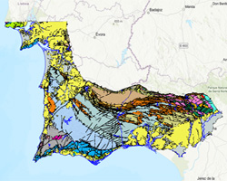
Potential Areas of Mineral Resources in Portugal
Year : 2023
As part of the preparatory works for the Portuguese Strategy on Mineral Resources, LNEG prepared a map of the country’s mineral potential for 9 groups of mineral resources that can be classified as Mineral Deposits according to the Portuguese mining law. The mineral potential areas were determined by combining the spatial distribution of known mineral occurrences with the knowledge about favourable geologic units.
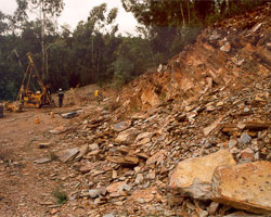
Schist Resources of Pedreira do Mestre André (Barrancos)
Year : 2001
The geological mapping of the area surrounding Pedreira do Mestre André in Barrancos was carried out in 2001, to support the evaluation of the resources available in this area for the production of shale for ornamental purposes. It was accompanied by a drilling campaign and a survey of the fracture state of the massif.
Cartography of Ornamental Limestones of the Maciço Calcário Estremenho
Year : 2014
The detailed geological mapping of the main ornamental limestone producing areas of the Maciço Calcário Estremenho in Portugal was prepared within the scope of Activity 1 – Sustainable Exploitation of Resources in the MCE of the project Environmental Sustainability of the Extractive Industry. This project, funded by European Structural Funds, was coordinated by ASSIMAGRA – Portuguese Association of Mineral Resources Industry. The disclosed geological maps allow us to know the spatial distribution of the limestone facies suitable for the production of ornamental limestones that have been in exploitation for about 3 decades and to evaluate the resources available in each of the 5 producing areas, which are integrated in the Natural Park of Serras de Aire e Candeeiros: Cabeça Veada, Codaçal, Moleanos, Pé da Pedreira and Portela das Salgueiras. These maps are the main support for mine planning by the extractive sector and also support the public entities responsible for land use planning. Still in the same project, but in the scope a general evaluation of the potentialities in ornamental limestones of the MCE, geological mapping at 1:25000 scale of other producing areas was also carried out, namely for the Moleanos - Ataíja de Cima and Moita do Poço regions in the municipality of Alcobaça and the region of Casal Farto in the municipality of Fátima.
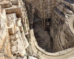
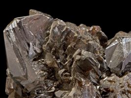
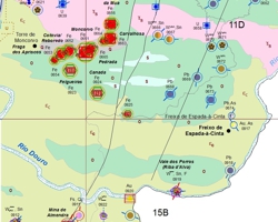
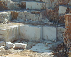
Geology of the Marble Exploitation Centers in the Estremoz Anticline
Year : 2012
The geological mapping of the marble exploration nuclei of the Anticlinal of Estremoz was carried out between 2003 and 2008 with a thematic focus on supporting the industrial sector and land planning. The maps produced for the 5 exploration centers, corresponding to the 5 Planning Units for the extractive industry defined in the PROZOM - Regional Plan for the Marble Zone, allow us to distinguish the main varieties of marbles, as well as their tectonic structuring that greatly conditions their exploitation.
GEO_FPI Project - Cross Border Observatory for the Iberian Pyrite Belt Geo-economic Valorization
Year : 2020
The Iberian Pyrite Belt (FPI), one of the most important Metallogenic Provinces in the world, articulates the core of the Alentejo-Algarve-Andalucía (A3) Euroregion, with a geological continuity that has fostered over the course of its history the economic, social and cultural development based on the exploitation of its mineral resources. This has led to a demography and economy strongly-dependent on the mining sector, this being the unifying element of the region. This common past focused on the mining activity and associated to a territory belonging to the same geologic domain, with 3 big common age sets between the Carboniferous and the Devonian ages (the Slaty-Quartzic Group, the Volcanic-Sedimentary Complex and the Flysch Group from Bajo Alentejo) has caused that nowadays, much of the important information generated in this environment, is scattered between various organisms, companies and institutions, extreme which limits largely the researches of geological, environmental, mining, historical and economic nature. This is the first major challenge to address, the integration of the base geological information, as well as that of stratigraphy and mining, properly grouped by means of GIS methodologies and valorized in the cross border context.
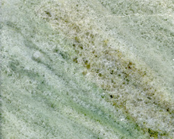
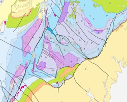
Geologic Map of the Marbles from Viana do Alentejo-Alvito, Portugal
Year : 1999
This geological map highlights the marbles of the region between Viana do Alentejo - Alvito, which corresponds to a fault-controlled anticlinal structure. The marbles surface in an extensive area and have coarse grain and greenish colors, being explored for many years in some quarries of relatively small dimensions.
Explora Project
Year : 2020
The EXPLORA project – Definition of new vectors of geological, geophysical and geochemical knowledge for the northern region of Neves-Corvo, funded by the Alentejo2020 program, aims to characterize the geological, geochemical and geophysical models of this important mining center of the Iberian Pyrite Range, up to depths of about 1500 m. EXPLORA intends to define new geological horizons favorable to the occurrence of sulphide mineralizations, based on an integrated ID methodology, which involves: the study of deep surveys (>1000 m); dating of felosic volcanic rocks (U/Pb in zircons) and sediments (biostratigraphic studies, palinology); processing and modeling of gravimetry, geomagnetism, resistivity and seismic data; petrophysical measurements; geochemistry of rocks and soils; study of geochemical halos in soils and software development.
Maps of Mineral Deposits of Portugal in the range of 1:200 000
Year : 2021
Over the last few years, the SIORMINP – Portuguese Mineral Resources and Occurrences System has been the basis for the production of the 8 sheets at the scale of 1:200 000 of the Mineral Deposits Charter of Portugal and also the leaf of the Northern Region. Here you can download the 8 sheets that make up the Letter of Mineral Deposits of Portugal on a scale of 1:200 000, complemented by their explanatory notes that include, in addition to an explanatory text on the letter, the lists with all 2443 mineral deposits of the country represented.
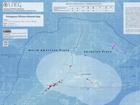
Portuguese Offshore Minerals Map
Year : 2021
The Offshore minerals map of Portugal was produced on a 1:5 000 000 scale, with the fundamental objective of demonstrating the potential of offshore Portuguese for mineral resources. For the construction of the map was considered the Exclusive Economic Zone of Portugal and the Proposal for extension of the Continental Shelf, which, being approved, will join the Zee's of the Azores, Madeira and mainland Portugal, increasing the area of portuguese jurisdiction and sovereignty to about 4 000 000 Km2.
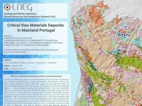
Critical Raw Materials Deposits in Mainland Portugal - CRM2020
Year : 2023
The search for new sources of raw materials, in particular, Critical Raw Materials, is conditioned by emergent technologies and economic factors. Raw Materials are considered “critical” when their supply risk and economic impact are considered high relative to others raw materials. The criticality of Critical Raw Materials depend on several geological, political, and technical factors. This “Critical Raw Materials Deposits in Mainland Portugal” map is a compilation of the known occurrences and deposits that contain some of the CRM according to the latest list published in December 2023.
Geological Map of the Brecha Algarvia Ornamental Limestone
Year : 2000
The Geological Map of Brecha Algarvia covers a large area in the Algarve region, between São Bráz de Alportel and Tavira. Realized at a scale of 1:5000, it highlights the Cerro da Cabeça Formation (Kimeridgian) as the lithostratigraphic unit which produces the variety of ornamental limestone known as “Brecha Algarvia” or “Brecha de Tavira”. Along with the performance of core drillings, it supported the delimitation of areas of best suitability for the exploration and safeguarding of this mineral resource and the calculation of the availability of resources.
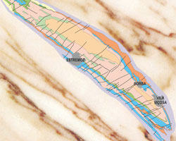
Geological Maps of the Estremoz Anticline, Portugal
Year : 1997
The anticlinal of Estremoz is one of the world's leading centers for the extraction of marble for ornamental purposes and is located in the northern sector of the Zona de Ossa – Morena (ZOM). Here you can download various geological cartography of resources from this zone.